Unlocking the Archaeology of the Severn
- 22nd April 2022
From the 8th April until 11th June an exhibition celebrating the Unlocking the Severn Project will be on show in The Hive. It is the culmination of a five-year project run by the Canal and Rivers Trust in partnership with Severn Rivers Trust, the Environment Agency and Natural England. Funding is being provided by the National Lottery Heritage Fund and the European Union LIFE Nature Programme, as well as The Waterloo Foundation and the partner organisations. The project aims to open up the river to additional species of fish through the installation of fish passes, alongside increasing knowledge and public engagement with the river and its wildlife.
Worcestershire Archive and Archaeology Service has placed a small exhibition on Level 2 at The Hive to complement the large exhibition in the atrium, looking at the importance of the river throughout human history in the County from the time our ancestors first arrived at least 500,000 years ago until today. Some of the artefacts mentioned below are on display in the cabinets and more information about those items can be found here. This is the first of three blogs; the second will look at the documentary research the service undertook for the Unlocking the Severn project and the third on the archaeology uncovered during the creation of the fish passes.
Although the Severn as it looks now didn’t exist until towards the end of the last Ice Age 12,000 years ago, where it flows through the county a river has flowed for over 200,000 years and the earliest gravel deposits below and around the river, date at the end of the Anglian glaciation 470,000 years ago when the huge ice sheet that covered most of Britain melted.
These layers of gravel and alluvial deposits contain animal bones, environmental evidence and occasional stone tools made by our ancestors. The bones and environmental evidence tell us about the environment our ancestors first inhabited. It’s not easy to reconstruct past landscapes as subsequent changes often result in the loss, relocation or burial of earlier deposits. In Worcestershire, our knowledge of the Ice Age comes from both geological and archaeological studies of preserved Ice Age deposits and the plant remains, animal fossils and human artefacts they contain.
Scientific dating techniques and geological deposit mapping help us to work out how the hills and rivers changed over time. The bones of large mammals can then tell us which species inhabited the landscape, which also gives us a general idea about the vegetation that might have grown. The Severn terrace gravel deposits are up to 10m deep in places and hold vital information that will allow us to reconstruct the county’s past environment.
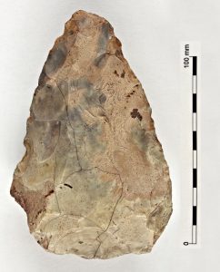
The Hallow hand axe. Found in Hallow near Worcester, it is 240,000 to 130,000 years old and was probably made by Neanderthal people
In Britain, the earliest human bone belonging to our own species, Homo sapiens, is a jaw fragment found in Kent’s Cavern in Devon. Scientific analysis estimates it to be at least 40,000 years old. Modern humans were highly adaptable and innovative hunter-gatherers who lived in larger groups with wider social networks.
Following the end of the last Ice Age, Worcestershire was sparsely inhabited by hunter-gatherer people during a period known as the Mesolithic. We find their tools across the county, including along the Severn where they must have hunted and lived. The major rivers would have provided corridors for movement of both early humans and the animals they hunted.
It is the late prehistoric where we start to see people settling and farming in this riverside landscape. The land overlooking the river would have provided ideal places to settle and the nature of gravel terraces mean that cropmarks survive up the river corridor of those settlements allowing us to see at a landscape-scale how and where they lived. Many of these settlements have been excavated, often in advance of quarrying the sand and gravel for development.
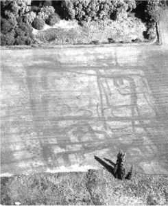
An example of how cropmarks are visible from the air showing past human activity, taken by former Worcestershire archaeological planning advisor Mike Glyde when he worked for the service
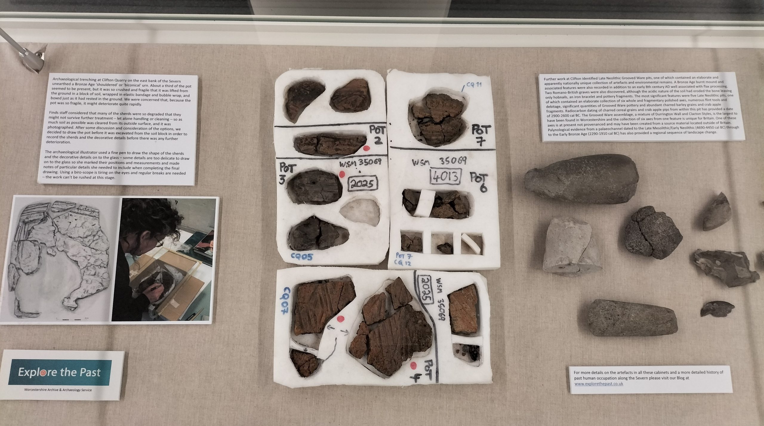
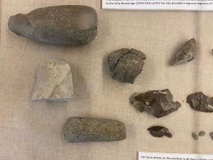
Clifton Quarry is one such site. Possibly the most significant features found on this site were five Late Neolithic pits, one of which contained an elaborate collection of six whole and fragmentary polished axes, numerous flint tools and debitage, significant quantities of Grooved Ware pottery and abundant charred barley grains and crab apple fragments. Radiocarbon dating of charred cereal grains and crab apple pips from within this pit has provided a date of 2900-2600 cal BC. The Grooved Ware assemblage, a mixture of Durrington Wall and Clacton Styles, is the largest to have been found in Worcestershire and the collection of six axes from one feature is unique for Britain. One of these axes is at present not provenanced and may have been created from a source material located outside of Britain. Palynological evidence from a palaeochannel dated to the Late Mesolithic/Early Neolithic (4690-4450 cal BC) through to the Early Bronze Age (2290-1910 cal BC) has also provided a regional sequence of landscape change.
The Severn has been an important source of trade and transport since Roman times. Evidence of this is found along its banks throughout the county, including on the site of The Hive before it was built. Alongside evidence for later periods, the excavations here uncovered the remains of several buildings. The buildings have been interpreted as commercial in function and perhaps represent a small-scale trading district that serviced riverside and roadside industrial working. Roman occupation was dated between the 1st century and the late 4th century AD, but was most intensive between the mid- to late 2nd century and the early 4th century. In this period the settlement at Worcester was at the height of its economic development, during which ironworking was a major focus, potentially alongside cattle trading. Evidence of this growing economy along the river can be seen in archaeological evidence across Worcester and further up and down the Severn.
As we move further forward in time the importance of the Severn as artery for trade grows. Settlements expand and evidence of prosperity can be seen. The river was navigable from Shrewsbury to the sea, although that did vary seasonally depending on whether the river was in flood or drought. The river was used to transport goods to and from all over the world.
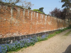
Evidence survives the length of the river that speaks of this rich heritage of trade. Sometimes it’s the small things that we barely notice that add to the character of an area and tell a small part of the story. Slag bricks are an example of this. It is likely that these blocks were manufactured either in Bristol (alongside the River Avon) or in Redbrook (alongside the River Wye) with waste from the copper smelting factories at those locations. Production of these slag blocks is believed to have taken place between 1750 and 1800. A survey was conducted recently in Gloucestershire and the slag blocks were recorded in several parishes on either side of the Severn estuary with the most northerly being two sites in Tewkesbury. No such survey has been carried out in Worcestershire but they are regular components of walls in towns and villages close to the Severn and the Stour throughout the County. It is believed that they were used as ballast and then discarded and reused.
The display will be on Level 2 in The Hive until mid June. In three cabinets until 25 May, and two cabinets after that.
Further reading
More details about the formation and geology of the River Severn
Information and resources about Ice Age Worcestershire
The mammoth radius found in Staffordshire
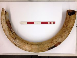
The mammoth tusk found at Clifton Quarry in 2016: A mammoth discovery – Worcestershire Archive & Archaeology Service (explorethepast.co.uk)
The Hive excavations: Archaeological excavation at the site of The Hive, The Butts, Worcester, Worcestershire Archaeology Research Report, 10.
The Unlocking the Severn Project can be found here: Unlocking the Severn | Canal & River Trust

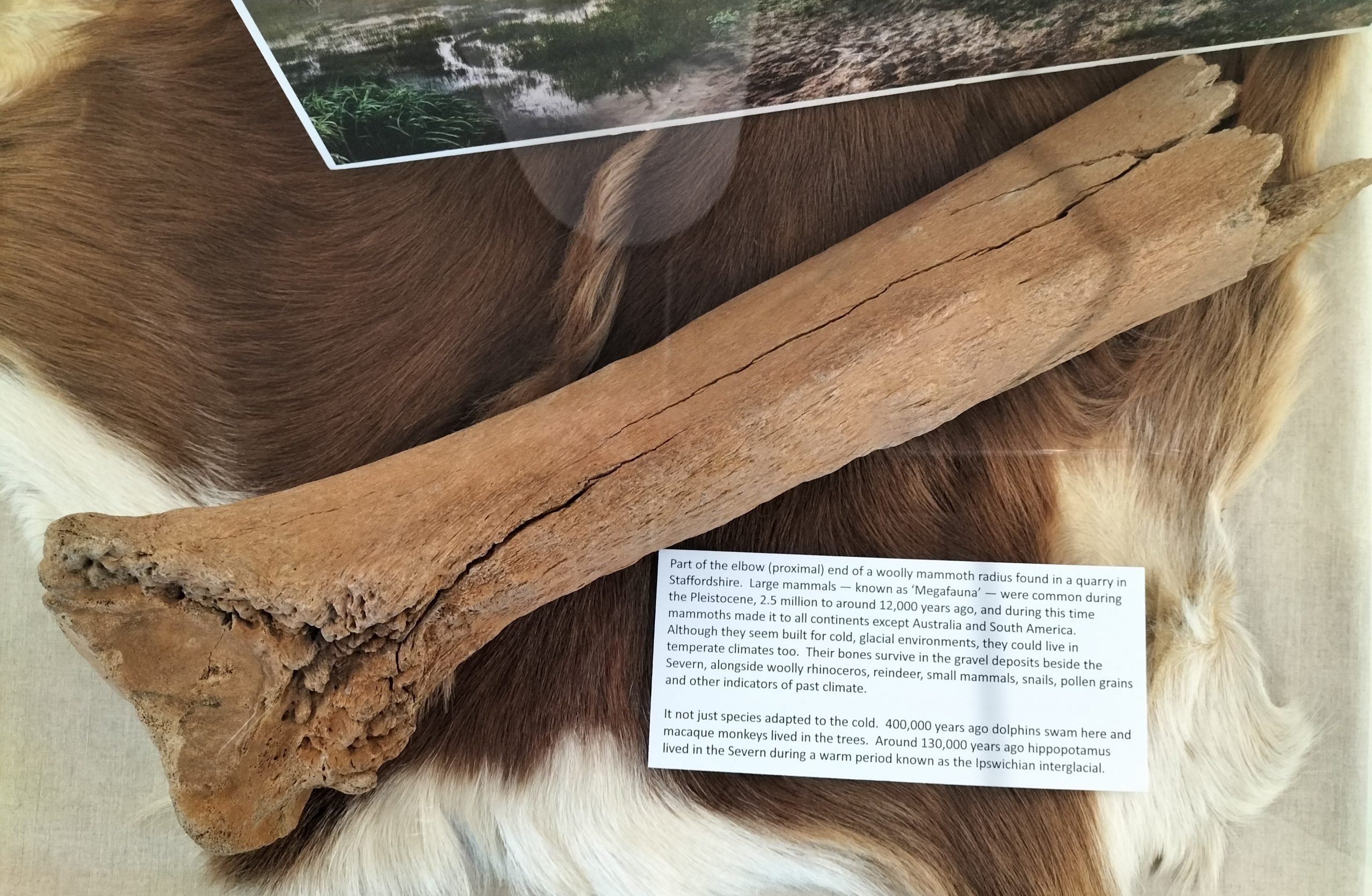
Mammoth bone (elbow) found by our archaeologists in Staffordshire
Thank you for this most interesting post.This ties in with a book I am reading by Graham Hancock about the last Ice Age.The book is called Magicians of the Gods Fascinating. !!